Drone News
TOPODRONE Launches AQUAMAPPER – DRONELIFE

 TOPODRONE Launches AQUAMAPPER Airborne Bathymetric Surveying Solution
by DRONELIFE Staff Writer Ian M. Crosby
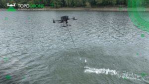
At global mapping show INTERGEO this week, LiDAR equipment company TOPODRONE has launched AQUAMAPPER, a UAV-based solution for bathymetric surveying and marine construction. Bathymetric surveying is the underwater equivalent of topographic surveying, mapping the floor of rivers, lakes and oceans. The new multitasking data collecting device has been successfully deployed alongside TOPODRONE LiDAR ULTRA equipment for the airborne surveying of a Romanian highway construction project in order to provide a digital twin of a scanned area.
The new AQUAMAPPER hardware integrates with other technology to form a comprehensive set of photogrammetry, LiDAR and bathymetry surveying solutions. Upon being mounted to a UAV, AQUAMAPPER offers high speed efficiency (up to 14 km/h) and accuracy. The PPK ready solution is also compatible with DJI Matrice 300 RTK. The…
Source: dronelife.com


