Drone News
Aloft Geo Portal FAA and Local Rules Together

 Aloft Launches Geospatial Management Tools for Drone Data Network
by DRONELIFE Staff Writer Ian M. Crosby
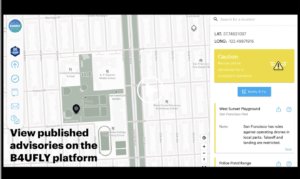
Today, drone airspace systems and UTM technologies leader Aloft Technologies released the Aloft Geo Portal, a free tool that brings together FAA airspace rules and local ground rules for drone operations nationwide.
Continue reading or listen below:
New submissions will gradually be published during the portal’s first phase, with the first set expected to publish in June. Essential for all drone flight, access to a reliable data set covering all air and ground requirements is especially crucial for the future of drone delivery and air taxi use cases.
“We’re connecting the dots between drone operators, local governments and comprehensive rules of operations to the largest and most active drone flight data network,” said Jon Hegranes, CEO and Founder of Aloft. “As it exists today, there’s a major information awareness gap in the industry and for…
Source: dronelife.com


