Drone News
Pix4D Donates Pix4Dreact to Non-Profits

 Pix4D is on the floor at AUVSI Xponential in Atlanta this week, demonstrating their suite of mapping products. One of these is Pix4Dreact, the fast mapping product for emergency response applications.
In this unprecedented time, the need for disaster response tools is greater than ever. Pix4Dreact is the perfect tool for rescue agencies working on search and rescue and other applications that require rapid processing to give an immediate situational awareness.
“PIX4Dreact is a 2D fast-mapping software that creates maps from drone images in minutes without an internet connection. Designed to meet the needs of public safety and humanitarian aid professionals, we’re offering this software for free to Non-profit Search & Rescue organizations in the US,” says Pix4D.
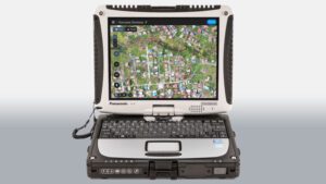
DRONELIFE first saw Pix4Dreact demonstrated in 2019. Designed with absolute practicality in mind, Pix4Dreact is made to work on the standard Toughbooks used by many public safety departments. Pix4Dreact has
Source: dronelife.com


