Drone News
Colorizing Lidar: SimActive and LiDARUSA Partner

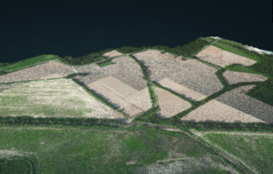 Light Detection and Ranging (Lidar) imagery offers high resolution models of ground elevation, with vertical accuracy. As Lidar sensors have gotten smaller and lighter for use on drones, the use cases have expanded. Lidar imagery is flexible and precise, which makes it useful for professionals who want to understand a surface. With Lidar, users can see the ground beneath the tree cover, or with Bathymetric LiDAR, the riverbed beneath the water. Lidar’s high resolution maps are used for applications that range from archeology to disaster management.
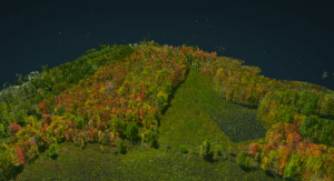
Lidar data can be tricky to understand, however. Without the context of traditional imagery, Lidar requires users to interpret what they are seeing. Lidar scanners don’t typically capture color, including only elevation or intensity values.
 SimActive Software Used to Colorize Lidar
Now, SimActive Inc. announces the use of its lidar point cloud colorization capabilities by users of multi-sensor systems…
Source: dronelife.com


