Drone News
Drones to Manage Powerline Vegetation

 Routescene case study demonstrates the benefits of using drones to manage powerline vegetation.
by DRONELIFE Staff Writer Ian M. Crosby
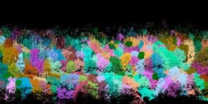
The latest in a series of forestry based case studies conducted by Routescene showcases the value of remote sensing techniques like UAV LiDAR for identifying diseased or damaged trees and overgrown vegetation close to powerlines to prevent outages or forest fires.
The project at Pound Farm in Suffolk, UK sought to identify ailing trees and overgrown vegetation that posed a risk of damaging the 33kV power lines running through the 120 acre forest. Routescene collaborated with 2Excel Geo, Fera Science and Dielmo 3D in order to provide the results to the Woodland Trust that owns the land.
In recent years, the forest has been affected by the highly destructive fungal disease known as Ash dieback. Capable of killing ash trees quickly, its symptoms include a blackening and wilting of leaves in mid to late summer.
 LiDAR, RGB, Multispectral…
Source: dronelife.com


